


Les cheres Morancé 17k

ophness
User
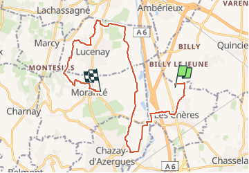

Length
17.4 km

Max alt
312 m

Uphill gradient
207 m
Km-Effort
20 km

Min alt
171 m

Downhill gradient
179 m
Boucle
No
Creation date :
2024-11-27 09:35:51.0
Updated on :
2024-11-27 09:35:52.648

FREE GPS app for hiking
 SityTrail
IGN / Geographical institutes
SityTrail Plus
The world is yours!
About
Trail of 17.4 km to be discovered at Auvergne-Rhône-Alpes, Rhône, Les Chères. This trail is proposed by ophness.
Positioning
Country:
France
Region :
Auvergne-Rhône-Alpes
Department/Province :
Rhône
Municipality :
Les Chères
Location:
Unknown
Start:(Dec)
Start:(UTM)
635182 ; 5084369 (31T) N.
Comments